


Trinder Square
Location
Eastern Cape > Gqeberha > Central
Eastern Cape > Gqeberha > Central
Add to travel planner
Description
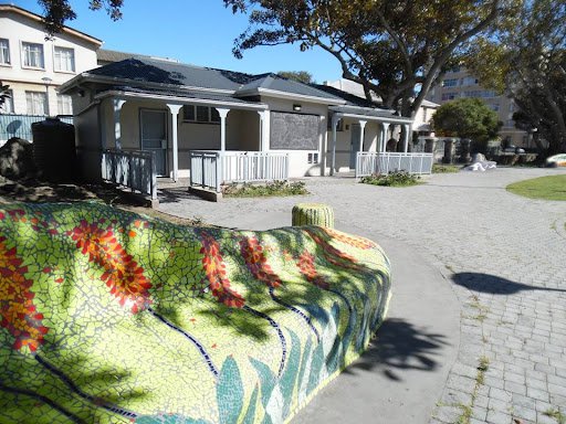
Trinder Square, located in Gqeberha (Port Elizabeth) Central, began life as a natural vlei—a shallow pond used for watering livestock in the early 1800s. In 1883, it was drained and enclosed with iron railings, transforming the site into a landscaped public garden. Today, it is a small urban park boasting mosaic benches and playground facilities, popular among local residents and included on Route 67, the heritage art trail through the city
Trinder Square, located in the historic heart of Gqeberha (formerly Port Elizabeth), is a small urban park with deep roots in the city’s early development. Originally known as Trinder Vlei, the area was once a shallow natural depression that collected water and served as a vital watering hole for cattle and horses in the early 1800s. It played an important role during the early colonial period, when Port Elizabeth was still growing as a frontier town along the Eastern Cape coastline.
By the late 19th century, the vlei had become an unsightly and unhygienic presence in what was rapidly becoming a more formal and structured city center. In 1883, the local municipality decided to drain the vlei and transform the area into a landscaped public square. The transformation was largely motivated by surrounding landowners—many of whom had built elegant residences nearby—and who wished to improve the appearance and hygiene of the neighborhood. That same year, Trinder Square was enclosed with a low retaining wall and decorative iron railings, converting the once marshy vlei into a formal green space for public use.
Today, Trinder Square is a peaceful and well-maintained community park, often used by local residents and schoolchildren. It features shaded walkways, open lawns, children’s play equipment, and distinctive mosaic benches that reflect local heritage and creativity. One mosaic art piece represents the roots of the wild fig trees that once grew there—tying the square’s natural past to its modern purpose as a space of rest and reflection.
The park also forms part of Route 67, a heritage walking trail through Gqeberha that celebrates the life and legacy of Nelson Mandela through 67 public artworks. As part of this route, Trinder Square contributes to a larger cultural and historical narrative, making it a worthwhile stop for both locals and visitors interested in the city’s layered past.
While small in scale, Trinder Square offers a meaningful glimpse into Gqeberha’s evolution from frontier outpost to modern city. It stands as a living testament to urban transformation, civic pride, and the integration of art, history, and green space in the heart of the Eastern Cape.
MAP
Latitude : -33° 57' 51.17" S | Longitude : 25° 37' 2.42" E
Experiences
Image Gallery
Experience
Things to See and Do
Adventure & Sports
Wildlife & Nature
Parks & Gardens
Provincial Park


 Please wait!